Plan and profile of the line of route of the Montreal Ottawa and Georgian Bay Navigation to more mundane 1980's US road maps.
The majority of the road maps are
 Rand McNally and don't display a date or edition, which makes cataloguing quite frustrating. Comparing the streets to known dated maps would be too time consuming due to the sheer volume that need to be processed. Tucked in the bottom right corner of one map, I noticed a 10 digit number, discontented from any of the map content.
 Turns out this serial code contains the publication date. Road Maps.org has a simple breakdown of the code system used on both Rand McNally and Gousha maps. The serial number for the above map is 79604909-15, so 1979.
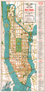
Within the mounds of donations, there were other undated maps. One of which was a Hagstrom NYC bus map that stood out because of it's design and colours. WorldCat.org suggested this was either from 1959 or 1969.
Hagstrom was considerably more cryptic about the dates of their maps then Rand McNally or Gousha. According to Gregory J. Christiano, this secrecy relates to copyright and marketing tactics, and was dropped in 1978.
The 3 to 4 digit codes used letters to tell the month and year of publication [mm]-[yy] based on the code below:

Our Hagstorm's map of New York (Manhattan) Bus Lines is coded A-RR, therefore published in February 1966. Below, in the larger section of the map, you can see the code at the bottom right corner. So, even the maps that seem mundane at face value have fascinating stories hidden in their lines and colours.


No comments:
Post a Comment